.svg)

St Thomas Way - 11. Longtown
Wales


.svg)
St Thomas - Longtown, 7 miles, 1 day
This walk is one of 13 separate circular routes which together make up the St Thomas Way.
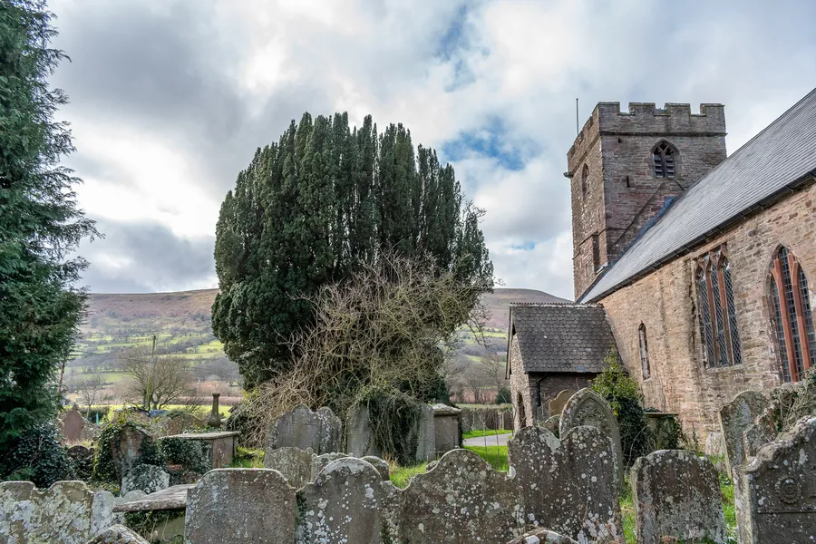
One of the lesser-known gems on the St Thomas Way, Longtown village and castle lie amid the awe-inspiring landscape of the Black Mountains.
Place and History
At the eastern edge of the Black Mountains, with the Hatterall Ridge to the west and Herefordshire’s Black Hill to the north, Longtown is set in an awe-inspiring natural landscape.
This striking topography speaks of political, as well as natural, power. The Offa's Dyke Path runs along the crest of the Hatterall Ridge close to the village (the line of the Dyke itself is slightly north-east of here), recalling King Offa's construction of a boundary between Anglo-Saxon Mercia and the Welsh kingdom of Powys in the eighth century.
The village of Longtown was founded as a Norman colony, in the Marcher Lordship of Ewyas.
Longtown Castle (also sometimes known as Ewyas Lacy Castle) was founded as a motte and bailey around 1175 by Hugh de Lacy. The impressive cylindrical keep was probably built in the 1220s by Walter de Lacy, in a phase of new works costing £37 – a large sum of money at that time. Unlike most Norman keeps, which were square, Longtown’s cylindrical keep was stronger and easier to defend.
The castle’s distinctive defensive structures indicate its role in protecting the town: it had three baileys and two larger enclosures, with much of Longtown today sitting inside the medieval castle site. The keep housed the private residence of the de Lacy family, while local people from Longtown would have worked as servants and in the wider castle enclosure.
The castle fell into decline in the fourteenth century, but was fortified once again by Henry IV during the Owain Glyndŵr uprising in 1403. In the Early Modern period, stone from the castle was re-used to make local buildings, and shops and houses were built in the bailey and leaning against the castle walls.
Recent archaeological digs and new research are extending our understanding of Longtown Castle, as well as the nearby Ponthendre earthworks – possibly a Norman motte and bailey castle which was begun but never completed, and was intended to serve as a look-out post for Longtown.
The Hanged Man's Journey
The witness statements given by those who saw the hanging – and strange revival – of William Cragh in Swansea, in 1290, show the distinctively medieval ways in which people understood and described the landscape around them.
Rather than using modern terms of measurement, the witnesses draw on their own experience to explain space and time.
For example, when Adam of Loughor is asked where the gibbet (gallows) of Swansea is located, he says that it’s ‘about two crossbow shots’ away from the town walls.
Henry Skinner is asked how long Cragh was hanging on the gallows, and answers that it was the length of time ‘in which time he estimated a man would be able to walk at a common pace quarter of one mile’.
After the recovering William Cragh first opens his eyes, he closes them again, according to John of Baggeham ‘for such a time that a man could walk one mile’. Other ways of referring to time include the canonical hours – such as ‘nones’ (the ninth hour, which corresponds roughly to ‘noon’) or ‘Vespers’ (in the evening), and the calendar of the church year (days such as All Saints and Michaelmas).
In a time before rulers and clocks, space and time were understood and measured through patterns of behaviour and embodied experience.
St Thomas and Medieval Belief
The ‘Other’ St Thomas
If you’ve heard of a medieval St Thomas, chances are it’s not St Thomas of Hereford.
Perhaps the most famous saint from medieval Britain is Thomas Becket. He was the son of a wealthy London merchant, and had a background in politics and the court, becoming Chancellor under Henry II. In 1162, Henry made him Archbishop of Canterbury. But this new role changed Thomas’s priorities and concerns: he now took the side of the church in disputes with the king, much to Henry’s anger. Thomas was forced into exile in France for several years, returning in 1170. Henry II was now on the throne: he had been crowned without the authority of Thomas and Canterbury, and Thomas had excommunicated those involved.
On 29 December, 1170, Thomas Becket was assassinated in Canterbury Cathedral, by a group of knights loyal to Henry II.
Henry’s famous words to them, according to tradition, had been ‘Who will rid me of this turbulent priest?’. The top of Thomas’s head was struck off and, according to medieval sources, local people collected the blood. Miracles began to happen straight away. The popularity of the cult of Thomas Becket was a major driver of pilgrimage in medieval Britain. The pilgrims in The Canterbury Tales – the famous medieval poem by Geoffrey Chaucer – are on their way to Becket’s shrine.
St Thomas of Hereford, though less well known today, was also an extremely important medieval saint. The miracle collection of Thomas of Hereford (that is, the medieval records of miracles linked to him) is second only to that of Thomas Becket. Like the cult of Thomas Becket at Canterbury, the cult of St Thomas of Hereford was a major draw for pilgrims, and had a huge economic and material impact on Hereford Cathedral.
Spiritual Reflection
A place reclaimed by nature
In the days when William Cragh and the de Briouze party made their pilgrimage to St Thomas’s shrine things were very different in Longtown. Standing in the long grass today it’s hard to envisage the planned medieval market town outside the ramparts of the twelfth-century Norman castle. About sixty years before William Cragh’s miracle Henry III had visited and ordered the garrison to be increased in size. Yet the town was not a success, perhaps because of the Black Death in the mid-fourteenth century. It gradually shrank in size and importance to become the village we see today. By the mid-fifteenth century the castle too had fallen into disuse and was a shadow of its former self. Today it is mainly absorbed back into the green countryside.
Prayer
Lord, things ebb and flow in the tide of history. Our best laid plans don’t always succeed. Grant us wisdom and humour to accept that what we create in good faith might not much outlast us, and so to put our trust in you, the Eternal Source of all that matters.
Natural World
The Black Mountains
The village of Longtown and the castle remains lie just to the east of the Hatterall ridge. The ridge is approximately 10 miles long and forms part of the Black Mountains, which creates a border between Powys and Monmouthshire, known as the Vale of Ewyas, in Wales and Herefordshire in England. Hatterall was formed around 60 million years ago, during the Devonian age, and is made up of Old Red Sandstone. The shape of the Vale of Ewyas to the west of the ridge indicates that a glacier once occupied the area during the last ice age.
The 'sheep district'.
The area around and including the modern village of Longtown was once known as Ewyas, or ‘the sheep district’. This name points to the significance of sheep farming to the areas both east and west of the Hatterall ridge.
Medieval Wool Trade
In medieval England and Wales, sheep farming was big business. The raw wool sheared from the sheep reared throughout this region would have been used locally to manufacture cloth and exported to the continent. As a result, the wool trade dramatically increased the wealth of the great landowners of the region, including the lords, abbots and bishops, and was another reason why the medieval March was such a desirable place to live.
Listen
Specially-chosen music for this location from Hereford Cathedral, and present-day ambient sound from Longtown Castle.
https://soundcloud.com/user-474556873/sets/longtown
***
Distance: Approx. 7 miles
Time: Approx. 3.5 hours
Access: Moderate-hard difficulty, country footpaths, some very steep inclines, footbridges and stiles; not suitable for wheelchairs and buggies; walking boots or other suitable footwear required
Directions
- Start your walk at Longtown Castle. The remains of the round stone keep date back to the twelfth century. As you leave the castle green, take the path immediately after the row of cottages opposite Llanwonog Lane, the site of a medieval dip well.Keeping the castle mound to your left, pass through the gate on the right. Keeping the hedgerow to your right, head across the field to the gate opposite. Continue through the next field in a roughly diagonal line to the left towards the gate in the hedge opposite, and then continue downhill to the left and head through into the next field. Continue walking to the left, gently downhill towards a stile halfway through the hedge.
- Climb over the stile and head in a diagonal line across the field to the gap in the hedgerow, go through this gap and continue along this line towards a waymark post and head down the path to cross the river via a small bridge. Climb over the stone stile opposite and continue through the field, keeping the river to your right, towards the stile and gate on the other side. Pass through the gate into the next field and continue forward to the next gate, keeping roughly to the right boundary and begin to follow the path as it goes uphill. If weather permits, you can walk through the smaller gate on the right and follow the path of the Holloway, or if the ground is muddy, continue through the field towards the gate ahead.
- Pass through the gate with the farmhouse to right and the barns to the left. Follow the track as it goes over a cattle grid. Take the road uphill to the left and follow the path until you reach a footpath sign pointing uphill to the left to Llanthony. Take this steep, uphill path.
- When you reach the top, join Offa’s Dyke Path and turn left. From the top of Offa’s Dyke path you will see Wales to the west and Herefordshire to the east. Continue along Offa’s Dyke Path until you reach a milestone pointing to Llanthony/Longtown. Llanthony Priory was an Augustinian monastic institution dating back to 1100.
- When you are roughly parallel with the church, take the path on the left towards Longtown, going back downhill. When the boundary fence appears on your right continue until you see a path between two boundary fences, taking the stile to the left into the field. Follow the right of way to bottom left corner of the field and climb the stile. Follow the fence downhill and about halfway down, turn right (you will see footpath arrows on your left, indicating the correct place to turn right). Cross the stile and continue in a straight line, following the waymark posts.
- Take the gate on the left and follow the steps down to the road and turn left. Follow the footpath up the verge, which will appear on the right. Head downhill through this field towards the stile about one third of the way down the boundary. In the next field, head to the bottom right corner and climb the stile, turning left to follow the fence to the gate.From here, you will be heading in the direction of St Clydawg’s Church, Clodock. The church is dedicated to St Clydawg, the king of Ewyas who was martyred in around 500AD. Pass through the gate and follow the fence at the bottom of the field, then follow the hedge to the bottom right corner and climb over the bridge stile over a small ditch. Follow the hedgerow and turn right over the next bridge stile, then turn left to the next stile cross the stream.
- Here, you will come out onto the road via another stile. Turn left up this road towards the church. Take the road to the right of the church, where you will find steps and stone stile up to the church on your left and Clodock Millon your right. Take the public footpath to your left and follow the river and then the stone stile into the churchyard. Cross over another stone stile to continue along this path, keeping the river to your right. Crossing over another stile, head slightly to the left towards a gate and pass into the next field, then cross a stone stile, where you will see a farm to your left. Follow this path to the road.
- From the road you will see the remains of an early Norman Motte and Bailey castle to your left. Head right over the bridge and cross the road to rejoin the footpath. Cross a stone stile to the left of the bridge, with the river to your left. Pass through this field to the stile on the right, and then take the gate onto the road, turning right until you reach a junction. Turn left and follow this road back to the castle and finish your walk.
Route highlights
.svg)


Location

Nearby Places
Nearby Sanctuaries
.avif)
.svg)
Discover holy places, and bring your own beliefs.
Pilgrimage by foot is connected with places and landscape, and how those places make you feel. Read about holy places.
At the British Pilgrimage Trust, we believe a pilgrimage should be made on an individual’s own terms. We are founded on the principle that we can all bring our own beliefs to the journey, accessible and welcoming to all.


.svg)
Comments
0 Comments
Login or register to join the conversation.
Tom Jones
Lorem ipsum dolor sit amet, consectetur adipiscing elit. Suspendisse varius enim in eros elementum tristique. Duis cursus, mi quis viverra ornare, eros dolor interdum nulla, ut commodo diam libero vitae erat. Aenean faucibus nibh et justo cursus id rutrum lorem imperdiet. Nunc ut sem vitae risus tristique posuere.